Tornado warnings were issued throughout the tri-county area the night of April 5 as severe weather battered South Carolina’s southern tip.
The National Weather Service’s Charleston office issued tornado warnings for Charleston, Berkeley and Dorchester counties beginning at 7 p.m. as severe thunderstorms blew through the region.
The last tornado warning expired by 8 p.m., though a tornado watch continued for the region until 9 p.m.
A severe thunderstorm warning remained in effect for Berkeley and Charleston counties until 9 p.m., as forecasters warned that wind gusts up to 70 mph and penny-size hail was likely to damage trees and powerlines.
At 9 p.m., more than 12,400 residents in Charleston County were reported to be without power, according to poweroutage.us, a website that tracks outages across the United States.
More than 9,000 of those outages were reported by customers of Dominion Energy.
Charleston Police Department reported before 9 p.m. on Twitter that significant outages in the city were causing traffic signals to be nonfunctional or on flashing status.
“Please use caution if you’re traveling throughout Charleston,” the department said.
More than 1,500 residents were without power in Dorchester County, while about 400 outages were reported in Berkeley County, according to the website.

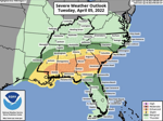
The Weather Service did not expect to issue a tornado watch for the Charleston area, which would mean atmospheric conditions are favorable for forming a tornado. National Weather Service/ Provided
The Weather Service issued a tornado watch for the region in the late afternoon.
A “watch” means atmospheric conditions are favorable for forming a tornado. A tornado warning is more serious — a potential tornado could be spotted or expected.
The Weather Service issued tornado warnings rapid fire beginning around 4 p.m. for counties in southwest South Carolina, including Bamberg, Orangeburg, Colleton, Beaufort and several towns across the state as severe thunderstorms passed through the region.
At about 5:40 p.m., lawmakers at the S.C. Statehouse paused their session and were evacuated due to a tornado warning issued in Columbia.
A tornado emergency was issued for Allendale after a tornado was spotted in the area headed toward Sycamore. Photos of tangled power lines, uprooted trees and fallen branches in Allendale were posted to social media in the hours after the storm barreled through the county.
Allendale County Manager William Goodson told The Associated Press that a tornado, captured in a video on social media, caused damage in his rural county, but exactly how much and whether there were any injuries were unknown.
“I know we have buildings damaged and power lines down,” Goodson said. “My deputies and emergency officials are out there assessing it.”
At least one person was reported to have suffered injuries that were not life-threatening in Allendale, the S.C. Emergency Management Division reported at 7:15 p.m. on Twitter. The agency said there were no reports of deaths as a result of the storm at that time.
The Red Cross of South Carolina opened a shelter at Allendale-Fairfax Elementary School for residents impacted by the storm, according to the agency.
Severe thunderstorms were expected to impact most of South Carolina and other states in the U.S. Southeast through the evening, bringing hail and damaging wind gusts higher than 60 mph, according to the Weather Service.
Institutions across the southern tip of the state closed ahead of the inclement weather forecast. The Charleston County School District canceled all after-school activities for April 5, according to a spokesman.
The county’s public libraries closed at 4 p.m., and recreation centers closed an hour thereafter.
Trident Technical College and S.C. State University also closed in the afternoon.

Severe thunderstorms were predicted to impact most of South Carolina and other states in the U.S. Southeast starting this evening. National Weather Service/ Provided
Lowcountry residents should look out for fallen tree limbs or tangling power lines on the roadways. The Charleston area was forecast to get between 1 and 1½ inches of rain, which could lead to minor flooding in low-lying areas, such as the downtown peninsula.
The rain was forecast to continue April 6, according to the Weather Service.
“It looks like there will be another round of showers and thunderstorms later tomorrow afternoon into the evening or overnight,” said Rebecca Davidson, a Weather Service meteorologist.
Residents should keep an eye on storm alerts as the forecast develops.
Call Olivia Diaz at 843-901-2995. Follow her on Twitter @oliviardiaz.
!function(f,b,e,v,n,t,s)
{if(f.fbq)return;n=f.fbq=function(){n.callMethod?
n.callMethod.apply(n,arguments):n.queue.push(arguments)};
if(!f._fbq)f._fbq=n;n.push=n;n.loaded=!0;n.version=’2.0′;
n.queue=[];t=b.createElement(e);t.async=!0;
t.src=v;s=b.getElementsByTagName(e)[0];
s.parentNode.insertBefore(t,s)}(window, document,’script’,
‘https://connect.facebook.net/en_US/fbevents.js’);
fbq(‘init’, ‘973418816133033’);
fbq(‘track’, ‘PageView’);
//!function(f,b,e,v,n,t,s)
//{if(f.fbq)return;n=f.fbq=function(){n.callMethod?
//n.callMethod.apply(n,arguments):n.queue.push(arguments)};
//if(!f._fbq)f._fbq=n;n.push=n;n.loaded=!0;n.version=’2.0′;
//n.queue=[];t=b.createElement(e);t.async=!0;
//t.src=v;s=b.getElementsByTagName(e)[0];
//s.parentNode.insertBefore(t,s)}(window, document,’script’,
//’https://connect.facebook.net/en_US/fbevents.js’);
//fbq(‘init’, ‘973418816133033’);
//fbq(‘track’, ‘Subscribe’, {currency: “USD”, value: XXXXXX}); //moved/already exists in


